Techture delivers Civil and Utilities BIM Services across Canada, supporting surface modeling, corridor modeling in Civil 3D, and utilities network BIM modeling for infrastructure projects of all scales. Our civil BIM services in Canada cover everything from site development to large-scale transportation and municipal infrastructure.
From surface modeling BIM and grading design to underground utilities BIM coordination across water, sewer, drainage, gas, and telecom networks, every deliverable is structured to support real-world construction, reduce clashes, and streamline approvals across Canadian infrastructure projects.
With a team of 350+ BIM professionals and strong familiarity with Canadian standards, we provide infrastructure BIM in Canada that integrates seamlessly with the workflows of civil engineers, municipal contractors, and infrastructure developers. Our expertise in Civil 3D services in Canada ensures accurate, coordinated models aligned with authority requirements.
Techture reviews project briefs, survey data, design drawings, utility records, and authority requirements. Scope, deliverables, and software environments are defined early, including alignment files and pipe network data for corridor and utilities projects.
Civil 3D environments are configured with appropriate surface structures, corridor assemblies, pipe network settings, and drawing templates. Coordinate systems and GIS integrations are aligned to match client or authority requirements.
Surface, corridor, and utility models are developed progressively and reviewed internally for accuracy and constructability. Grading, alignments, and network routing are validated before sharing with project stakeholders.
Models are coordinated with structural and MEP disciplines where applicable. Clash detection identifies utility conflicts and interface issues, and Techture supports iterative resolution until the model is construction-ready.
Final deliverables include drawings, schedules, quantity sheets, and phasing documentation.Models are issued in agreed formats such as Civil 3D, IFC, or GIS-compatible outputs for authority submission and asset management.
Techture supports civil engineering consultants by handling BIM production for surface modeling, corridor modeling in Civil 3D, and utilities network design. This allows engineering teams to focus on design development, analysis, and approvals while ensuring high-quality, standards-compliant deliverables aligned with Canadian project requirements.
For municipalities and public sector authorities managing infrastructure BIM in Canada, Techture provides accurate BIM models and documentation aligned with provincial submission standards and GIS-based record systems. This supports efficient planning, approvals, and long-term asset management.
Techture supports general contractors with coordinated civil BIM models, clash-free underground utilities BIM layouts, and construction-ready documentation. This enables better planning, improved site coordination, reduced rework, and smoother execution across complex infrastructure projects.
Land developers benefit from precise surface modeling BIM, grading design, and coordinated utilities layouts for site development projects. Techture’s outputs support planning approvals, servicing strategies, and construction documentation across residential, commercial, and industrial developments in Canada.
We work with multiple Design Consultants and offer our BIM solutions

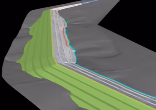
The civil and utilities BIM services entail designing coordinated three-dimensional digital models of the terrain, corridor, and utility network below ground for purposes of design, coordination, and construction. Techture’s service scope entails surface modeling, corridor design, utilities modeling, coordination, and documentation.
Techture mainly makes use of Autodesk Civil 3D for modeling, Navisworks for coordination and clash detection, and InfraWorks for conceptual planning of infrastructure projects. We adjust to your project's software environment and coordinate system for maximum service delivery to you.
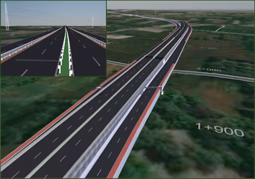
Corridor modeling is the creation of a 3D parametric model of linear infrastructure such as roads or railways, including geometry, cross-sections, and earthworks. Techture delivers corridor models in Civil 3D from design through to construction documentation.
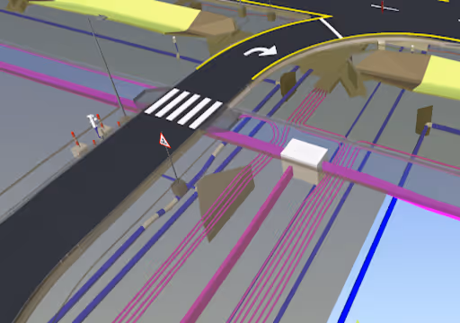
Yes, Techture models water, sewer, drainage, gas, and telecom networks in 3D. These are coordinated with other disciplines and delivered in Civil 3D or GIS-compatible formats aligned with municipal standards.
Civil BIM identifies clashes, grading issues, and design conflicts before construction begins. This reduces costly rework, delays, and uncertainties by providing a coordinated and verified model for execution.
Yes, Techture supports both urban and rural infrastructure projects, including highways, regional roads, and utility corridors. Our workflows scale to project size and geographic complexity.
Deliverables include 3D models, plan and profile drawings, cross-sections, quantity sheets, utility schedules, clash reports, and GIS-compatible exports. All outputs are aligned with client and authority submission requirements.


